El Niño is a natural climate phenomenon that influences ocean temperatures, rainfall patterns and extreme weather events across different parts of the world. In 2026, the phenomenon is intensifying unusually rapidly, with potentially significant consequences for marine ecosystems, coral reefs and marine heatwaves. But what is El Niño, why is it strengthening, and how could it affect the Mediterranean? Here is what you need to know about the connection between El Niño, the ocean and climate change.
What Is El Niño?
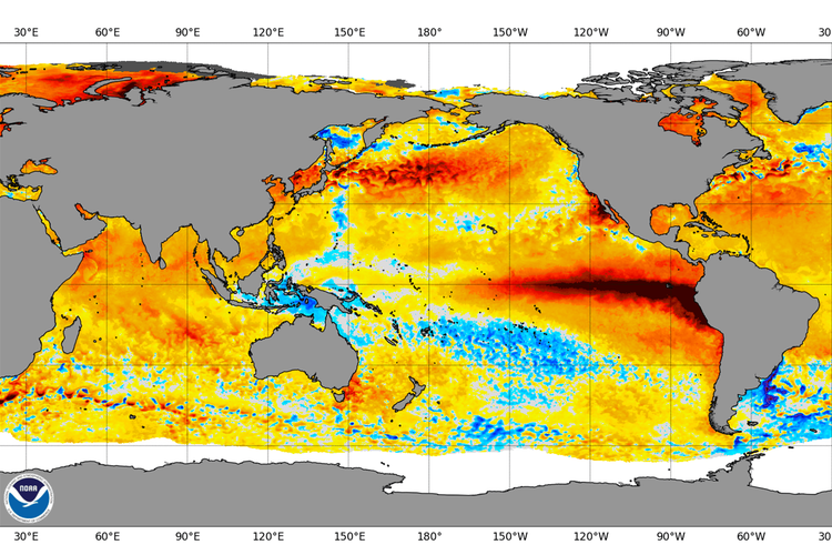
El Niño is the warm phase of ENSO (El Niño–Southern Oscillation), a natural climate pattern involving interactions between the ocean and the atmosphere in the tropical Pacific. Under normal conditions, trade winds push warm surface waters westwards towards Indonesia and Australia, while cold, nutrient-rich deep water rises to the surface along the coast of South America. During El Niño, the trade winds weaken, warm water shifts eastwards, and the central and eastern Pacific experience unusually high sea surface temperatures.
The atmosphere responds to these changes, affecting convection, rainfall and large-scale air circulation patterns that connect regions thousands of kilometres apart. El Niño is not a new phenomenon. According to the World Meteorological Organization (WMO), El Niño events typically occur every two to seven years and usually last between nine and twelve months. What makes the 2026 event exceptional is its intensity.
What Happens to the Ocean During El Niño?
To understand El Niño’s impact, it is important to remember that the ocean absorbs more than 90% of the excess heat trapped in the climate system by greenhouse gases. El Niño does not create this heat, but redistributes it, bringing some of the heat stored in the ocean to the surface and adding to the effects of long-term warming. While El Niño has intensified short-term temperature increases, the underlying long-term warming trend is still driven by human activity.
The consequences for marine ecosystems are well documented. NOAA climatologist Dillon Amaya explains that El Niño tends to trigger intense and widespread periods of extreme ocean warming, known as marine heatwaves. These can have cascading effects, including coral bleaching, harmful algal blooms, declines in seaweed populations and an increase in marine mammal strandings.
Fisheries are also affected. Along the eastern Pacific coast, the weakening of cold-water upwelling reduces nutrient availability and can lead to lower fish abundance. In Pacific and Indian Ocean island nations, meteorological services warn that marine heatwaves threaten coral reefs and can alter the distribution and availability of commercially important fish species. For example, the Maldives Meteorological Service identifies marine heatwaves and coral reef degradation among the key impacts of ocean warming.
The link between El Niño and coral bleaching is also the subject of recent research. A study presented at the 2026 EGU General Assembly, focusing on the Andaman and Nicobar Islands, found a strong association between intense marine heatwaves and widespread coral bleaching during strong El Niño years. The findings indicate that cumulative thermal stress exceeding 4°C-weeks is the strongest predictor of severe bleaching.
What Lies Ahead This Autumn? El Niño Is Heading Towards Record Levels
The development of this El Niño event has been rapid. In March, NOAA estimated a one-in-three chance of a strong El Niño developing between October and December. By July, the probability of a “very strong” event had risen from 63% to 81% in just one month. In its 10 September update, NOAA reported that El Niño was continuing to strengthen, with a greater than 90% probability of a very strong event during the 2026–27 Northern Hemisphere autumn and winter.
According to the latest update from the World Meteorological Organization (WMO), published on 8 October 2026, El Niño is continuing to intensify rapidly and could become one of the strongest events recorded since 1950. Sea surface temperatures in the central and eastern tropical Pacific are forecast to reach an anomaly of around +3.7°C above average between October and December, surpassing the previous record of +2.6°C recorded between November 2015 and January 2016.
The event is expected to peak in December, with the probability of El Niño persisting until February 2027 approaching 100%. This is particularly significant because the phenomenon is developing in an ocean that is already exceptionally warm. August 2026 recorded the highest global average ocean temperature ever observed.
El Niño does not add new heat to the climate system; instead, it redistributes some of the heat already stored in the ocean towards the surface. An event of this intensity can therefore amplify temperature extremes and alter rainfall patterns across different regions of the world, increasing the risk of droughts, floods and heatwaves.
El Niño and the Mediterranean: An Indirect Effect on an Already Stressed Sea
Unlike the Pacific, the Mediterranean is not directly affected by El Niño. Europe is influenced mainly through indirect atmospheric connections, and the phenomenon could contribute to a milder autumn and fewer cold-air outbreaks across southern Europe during the 2026–27 winter. The WMO also notes that forecasts for Europe are less reliable than those for many other regions. The most noticeable effects are expected to emerge later, from the coming winter into the summer of 2027.
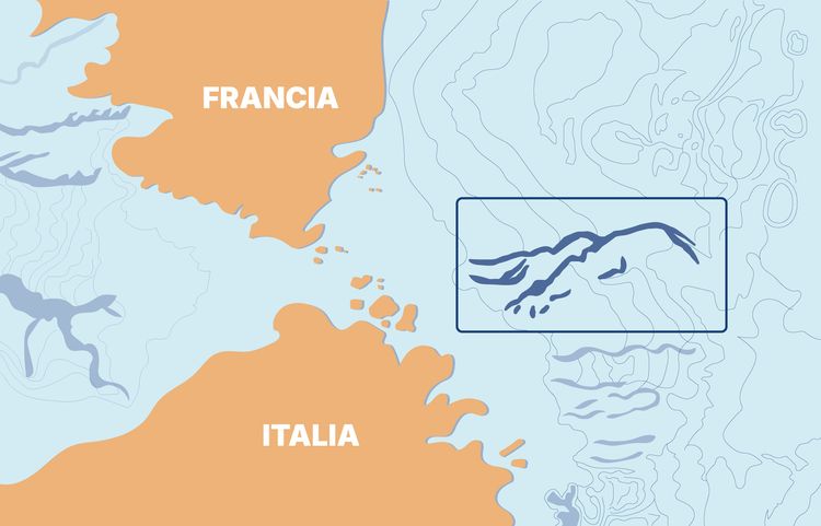
The key concern for the Mediterranean is that El Niño is developing against a backdrop of already exceptional ocean temperatures. According to Copernicus, by late June, sea surface temperatures in the western Mediterranean had reached anomalies of around 6°C above average, particularly in the Ligurian and Tyrrhenian seas. During the first six months of 2026, marine heatwaves affected 98% of the Mediterranean basin, while June recorded a record average sea surface temperature of 24.3°C.
In July, the Copernicus Climate Change Service (C3S) reported record temperatures for the month in the western Mediterranean and along the Atlantic coast, with marine heatwaves reaching strong to severe intensity.
Weather and climate bulletins link the strengthening of El Niño to exceptional temperatures in the equatorial Pacific, not to the Mediterranean records themselves. These local extremes are part of a broader warming trend driven by climate change. The concern is that El Niño could compound this trend: Copernicus warns that further records may be broken in the coming months. The consequences affect marine species, Posidonia oceanica seagrass meadows and fisheries, all of which are already under pressure. This reinforces the importance of monitoring and protecting coastal habitats.
El Niño is a reminder of how closely climate, the ocean and society are interconnected. A marine heatwave can affect a coral reef, a fishing industry or a coastal area thousands of kilometres from where the phenomenon originates. Monitoring scientific data, supporting research and protecting ecosystems that strengthen resilience — including coral reefs, mangroves and seagrass meadows — are among the most effective ways to mitigate these impacts.
Read more articles
Global Patterns of Mercury Speciation and Biomagnification in Sharks: Ecological Drivers and Food Safety Implications
Evaluating Leaf Area and Biomass Relationship in Posidonia oceanica (L.) Delile: A Tool for Non-Destructive Assessment